McCasland's Figure 2 Ranch
Arthur, NE 69121
Arthur County, Nebraska
Farm Description
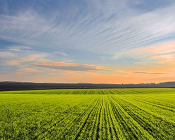
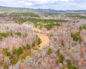
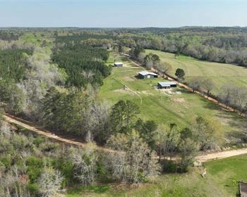
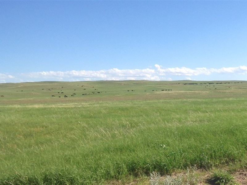
The McCasland Figure 2 Ranch is comprised of approximately 10,292.90 deeded acres by county record. It consists of six non-contiguous land tracts that support three center pivots, native Sandhill rangeland and one building site. The West Tract comprised of 3,285.20 deeded acres consists of three Sandhill rangeland pastures - one in Garden County and two in Arthur County. Stock water consists of five solar wells and one windmill. All of the stock tanks are 30 foot tanks with two newly installed within the last three years. It is an all contiguous unit and has legal access via county gravel road at the west end of the property. The Home Tract is the headquarters-building site and consists of 5,342.21 deeded acres. It is comprised of ten main Sandhill rangeland pastures with several small pasture/lots located around the building site. Stock water is provided by five solar wells, six windmills, along with five tanks that have their source via underground pipeline that originates at the building site. Nearly all of the stock tanks are 30 foot tanks. It is an all contiguous unit and has legal access via county road that traverses east to west through the northern portion of this ranch unit. The unit has very good access through the entire ranch by county road. Building Improvements ON The Home Tract Main Home - One Story - 1800 SQ FT - New in 2012 Older Main Home - Story and One Half - 2,792 SQ FT - 1920 Bunk House - One Story 636 SQ FT - 1930 Farm/Lean to Utility Building - 3,300 SQ FT - New in 2017 Quonset Building - 2,400 SQ FT Quonset Building - 1,584 SQ FT Barn - 1,728 SQ FT Indoor Arena - 22,500 SQ FT The Home Pivot Tract consists of 192.81 deeded acres and is located approximately two miles south via county gravel road from the Home Tract and building site. It has legal access from the county gravel road one quarter of a mile away. It has 162.45 Certified Irrigated Acres registered with the Twin Platte Nrd, North Platte, NE. It has an 11 tower Zimmatic electric center pivot, powered by an Isuzu diesel motor. There is a solar well with a 30 foot tank located on the home pivot tract. Irrigation Well Data Well Registration - G-044752 Well ID -52103 Well Depth -240 feet Static Water Level -10 feet Pumping Level -100 feet GPM - 1000 Tpnrd - CIAs 162.45 Date Filed - 1975 Owner - Figure 2 Ranch The Northeast Development Tract consists of 551.35 deeded acres is located one mile northeast from Arthur NE and is bisected by State paved highway 61. It is currently Sandhill native rangeland. There are two solar wells each with 30 foot tanks on this tract, one on the west side and one on the east side of State highway 61.Because of its access and location it may be considered to have some higher and better use than Sandhill rangeland such as for some development potential other than rangeland. The Southwest OF Arthur Pivot Tract consists of 605.09 deeded acres and is located one mile southwest from Arthur, NE and has direct access to State Highway 61. It consists of two center pivots having a total of 220.01 Certified Irrigated Acres registered with the Twin Platte, Nrd, and North Platte, NE. The east pivot contains 84.729 Certified Irrigated Acres registered with the Twin Platte Nrd, North Platte, NE. The west pivot contains 135.284 Certified Irrigated Acres registered with the Twin Platte Nrd, North Platte, NE. The FSA 156Ez shows the pivots having a base acreage of 211.6 acres with a PLC Yield of 117 bushels of corn. The pivots are run by diesel power motors. There is one solar and one windmill for stock water on this tract. Irrigation Well Data - East Pivot Well Registration - G-064082 Well ID -72006 Well Depth -280 feet Static Water Level -26 feet Pumping Level -42 feet GPM - 1005 Tpnrd CIAs -84.729 Date Filed - 1980 Owner - Mark McCasland Irrigation Well Data - West Pivot Well Registration - G -064081 Well ID -72005 Well Depth -300 feet Static Water Level - 55 feet Pumping Level -75 feet GPM -1159 Tpnrd CIAs - 135.284 Date Filed - 1980Owner - Mark McCasland The South Tract consists of 316.24 deeded acres and is located eight miles south and one mile east from Arthur, NE. It is Sandhill Native Rangeland and has one solar well for stock water. The seller will provide legal access from the southwest for this rangeland tract. County gravel road is located one half mile south from this tract. History The first American/Europeans arrived in what is present day Arthur County from 1867-1890. Some had worked for the Union Pacific Railroad to get a grub stake to file a homestead. Some were Texans who found their way north bringing vast herds of cattle with them to ship out to Chicago along points at Ogallala eastward into central Nebraska. Texas outfits such as the Xit, Ubi, and the Turkey Tracks found open range in parts of the Sandhills and utilized large unfenced tracts of range for a period. The federal government opened up the region to formal settlement in 1884. By the 1900'S some of the land in McPherson County westward into Arthur County was under the ownership of ranches owned by Buffalo Bill Cody and the North Brothers. The first courthouse in Arthur County was in a covered wagon until 1915. The county seat of Arthur County is Arthur, the only town to this day in the county, was established in 1913 with a federal post office being established in 1914. In 1914 the Arthur State Bank was established, however, failed with the arrival of the Great Depression never to open again. Nebraska Sandhills The McCasland Figure 2 Ranch is located in the western region of the famed Nebraska Sandhills, known for one of the finest cattle producing regions in the United States. The Sandhills of Nebraska is the Nation's largest undisturbed native grassland area. It covers approximately 13 million acres in 20 counties located in the north central part of the state. The grasses are vigorous and nutritious and have proven themselves as drought tolerant species centuries ago by supporting vast herds of Buffalo prior to the arrival of the white man. Ogallala Aquifer The Sandhills of Nebraska also sits on top of the largest fresh water aquifer in the continental U.S. Known as the Ogallala or High Plains Aquifer, it supports fresh water bearing material where this ranch is located in the range of 600'-800' in depth. Stock wells and irrigation wells are generally considered shallow and abundant by comparison to other cattle producing regions in other states. Most of the stock wells on the ranch are 1-3 rods deep and in most cases can be pulled by hand to change leathers. Rainfall The rainfall belt in the area and location of this ranch ranges from 16 -19 per year with the majority of it falling during the grass growing season. It is generally considered consistent and reliable to the extent that cattle sell downs because of drought are rare. Markets The ranch is located within an hour's drive to one of the most established livestock auction barns in the state at Ogallala, Nebraska. Thousands of reputation cattle pass through its gates annually in the form of special stock cow, bred heifer, yearling, and calf sales throughout the year. Buyers from several states are always on hand to create a consistent, top-end market for all classes of cattle. There are also video auction markets available that are nationwide in scope. Minerals The current ownership will convey all the owned minerals. Exchanges The current ownership will cooperate with 1031 exchanges. Approach TO Management And Revenue The total of the ranch is made up of three center pivots with the balance Sandhill Native Rangeland. The center pivots are currently not into production of any annual crops. Annual crops have not be planted on the center pivots for several years. Management plays a big role relative to the AUMs of productivity from the center pivot sites.The ranch resource has